 |
 |
|
|
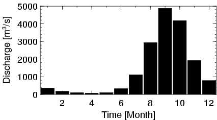
| Station Name (GRDC ID): | Koulikoro (1134100) | Basin Name: | Niger |
|---|---|---|---|
| River Name: | Niger | Next Downstream Station: | Kirango aval (1134250) |
| GRDC Country Code: | MI | Distance to Next Downstream Station: | 132 km |
| Start Year [Month]: | 1907 [1] | Upstream Station(s): | Selingue (1134050) Tiguibery (1634650) |
| End Year [Month]: | 1990 [12] | ||
| Mean Discharge: | 1407 m3/s | ||
| Minimum Discharge: | 4 m3/s | ||
| Maximum Discharge: | 8420 m3/s | Length of Upstream Mainstem: | 631 km |
| Mean Interstation Discharge: | 23 m3/s | Distance to Basin Outlet: | 2824 km |
| GRDC Catchment Area: | 120000 km2 | STN Catchment Area: | 121466 km2 |
| GRDC Interstation Area: | 15800 km2 | STN Interstation Area: | 18096 km2 |
| GRDC Station Runoff: | 370 mm/yr | STN Station Runoff: | 365 mm/yr |
| GRDC Interstation Runoff: | 47 mm/yr | STN Interstation Runoff: | 41 mm/yr |
| Station Field Descriptions | Basin Field Descriptions | ||
| Download | |
|---|---|
| Site Descriptor Information | Station Time Series Data |
| Hydrograph | Station Data | ||||||||||||||||||||||||||||||||||||||||||||||||||||||||
|---|---|---|---|---|---|---|---|---|---|---|---|---|---|---|---|---|---|---|---|---|---|---|---|---|---|---|---|---|---|---|---|---|---|---|---|---|---|---|---|---|---|---|---|---|---|---|---|---|---|---|---|---|---|---|---|---|---|
|
| ||||||||||||||||||||||||||||||||||||||||||||||||||||||||
