 |
 |
|
|
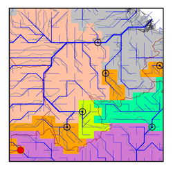
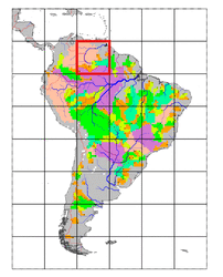
| Station Name (GRDC ID): | Uaracu (3618950) | Basin Name: | Amazon |
|---|---|---|---|
| River Name: | Rio Uaupes | Next Downstream Station: | Obidos (3629000) |
| GRDC Country Code: | BZ | Distance to Next Downstream Station: | 1842 km |
| Start Year [Month]: | 1977 [10] | Upstream Station(s): | None |
| End Year [Month]: | 1992 [5] | ||
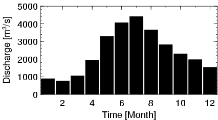
| Mean Discharge: | 2388 m3/s | ||
| Minimum Discharge: | 144 m3/s | ||
| Maximum Discharge: | 5716 m3/s | Length of Upstream Mainstem: | 546 km |
| Mean Interstation Discharge: | 2388 m3/s | Distance to Basin Outlet: | 2379 km |
| GRDC Catchment Area: | 40506 km2 | STN Catchment Area: | 37088 km2 |
| GRDC Interstation Area: | 40506 km2 | STN Interstation Area: | 37088 km2 |
| GRDC Station Runoff: | 1859 mm/yr | STN Station Runoff: | 2030 mm/yr |
| GRDC Interstation Runoff: | 1859 mm/yr | STN Interstation Runoff: | 2030 mm/yr |
| Station Field Descriptions | Basin Field Descriptions | ||
| Download | |
|---|---|
| Site Descriptor Information | Station Time Series Data |
| Hydrograph | Station Data | ||||||||||||||||||||||||||||||||||||||||||||||||||||||||
|---|---|---|---|---|---|---|---|---|---|---|---|---|---|---|---|---|---|---|---|---|---|---|---|---|---|---|---|---|---|---|---|---|---|---|---|---|---|---|---|---|---|---|---|---|---|---|---|---|---|---|---|---|---|---|---|---|---|
|
| ||||||||||||||||||||||||||||||||||||||||||||||||||||||||
