 |
 |
|
|
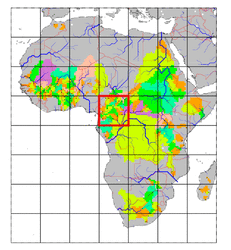
| Station Name (GRDC ID): | Ngbala (1448050) | Basin Name: | Zaire |
|---|---|---|---|
| River Name: | Dja | Next Downstream Station: | Ouesso (1448100) |
| GRDC Country Code: | CG | Distance to Next Downstream Station: | 190 km |
| Start Year [Month]: | 1954 [6] | Upstream Station(s): | Mbalmayo (1339500) |
| End Year [Month]: | 1978 [11] | ||
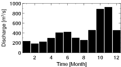
| Mean Discharge: | 420 m3/s | ||
| Minimum Discharge: | 91 m3/s | ||
| Maximum Discharge: | 1610 m3/s | Length of Upstream Mainstem: | 523 km |
| Mean Interstation Discharge: | 271 m3/s | Distance to Basin Outlet: | 1396 km |
| GRDC Catchment Area: | 38600 km2 | STN Catchment Area: | 40139 km2 |
| GRDC Interstation Area: | 25045 km2 | STN Interstation Area: | 27794 km2 |
| GRDC Station Runoff: | 343 mm/yr | STN Station Runoff: | 330 mm/yr |
| GRDC Interstation Runoff: | 341 mm/yr | STN Interstation Runoff: | 307 mm/yr |
| Station Field Descriptions | Basin Field Descriptions | ||
| Download | |
|---|---|
| Site Descriptor Information | Station Time Series Data |
| Hydrograph | Station Data | ||||||||||||||||||||||||||||||||||||||||||||||||||||||||
|---|---|---|---|---|---|---|---|---|---|---|---|---|---|---|---|---|---|---|---|---|---|---|---|---|---|---|---|---|---|---|---|---|---|---|---|---|---|---|---|---|---|---|---|---|---|---|---|---|---|---|---|---|---|---|---|---|---|
|
| ||||||||||||||||||||||||||||||||||||||||||||||||||||||||
