 |
 |
|
|
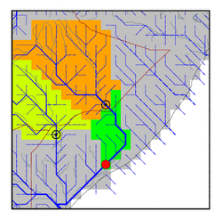
| Station Name (GRDC ID): | Afgoi (1878100) | Basin Name: | Jubba |
|---|---|---|---|
| River Name: | Shebelle | Next Downstream Station: | None |
| GRDC Country Code: | SI | Distance to Next Downstream Station: | N.A. |
| Start Year [Month]: | 1951 [4] | Upstream Station(s): | Belet Uen (1878500) |
| End Year [Month]: | 1979 [2] | ||
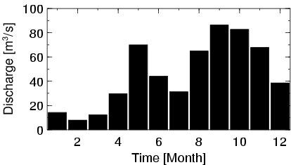
| Mean Discharge: | 46 m3/s | ||
| Minimum Discharge: | 0 m3/s | ||
| Maximum Discharge: | 112 m3/s | Length of Upstream Mainstem: | 1329 km |
| Mean Interstation Discharge: | -22 m3/s | Distance to Basin Outlet: | 449 km |
| GRDC Catchment Area: | 278000 km2 | STN Catchment Area: | 270030 km2 |
| GRDC Interstation Area: | 66200 km2 | STN Interstation Area: | 52426 km2 |
| GRDC Station Runoff: | 5 mm/yr | STN Station Runoff: | 5 mm/yr |
| GRDC Interstation Runoff: | -11 mm/yr | STN Interstation Runoff: | -13 mm/yr |
| Station Field Descriptions | Basin Field Descriptions | ||
| Download | |
|---|---|
| Site Descriptor Information | Station Time Series Data |
| Hydrograph | Station Data | ||||||||||||||||||||||||||||||||||||||||||||||||||||||||
|---|---|---|---|---|---|---|---|---|---|---|---|---|---|---|---|---|---|---|---|---|---|---|---|---|---|---|---|---|---|---|---|---|---|---|---|---|---|---|---|---|---|---|---|---|---|---|---|---|---|---|---|---|---|---|---|---|---|
|
| ||||||||||||||||||||||||||||||||||||||||||||||||||||||||
