 |
 |
|
|
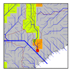
| Station Name (GRDC ID): | Chiromo (1992900) | Basin Name: | Zambezi |
|---|---|---|---|
| River Name: | Shire | Next Downstream Station: | None |
| GRDC Country Code: | MW | Distance to Next Downstream Station: | N.A. |
| Start Year [Month]: | 1953 [1] | Upstream Station(s): | Liwonde (1992700) |
| End Year [Month]: | 1981 [10] | ||
| Mean Discharge: | 486 m3/s | ||
| Minimum Discharge: | 22 m3/s | ||
| Maximum Discharge: | 1219 m3/s | Length of Upstream Mainstem: | 1077 km |
| Mean Interstation Discharge: | 14 m3/s | Distance to Basin Outlet: | 285 km |
| GRDC Catchment Area: | 149500 km2 | STN Catchment Area: | 147536 km2 |
| GRDC Interstation Area: | 19300 km2 | STN Interstation Area: | 23726 km2 |
| GRDC Station Runoff: | 102 mm/yr | STN Station Runoff: | 104 mm/yr |
| GRDC Interstation Runoff: | 23 mm/yr | STN Interstation Runoff: | 19 mm/yr |
| Station Field Descriptions | Basin Field Descriptions | ||
| Download | |
|---|---|
| Site Descriptor Information | Station Time Series Data |
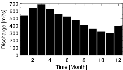
| Hydrograph | Station Data | ||||||||||||||||||||||||||||||||||||||||||||||||||||||||
|---|---|---|---|---|---|---|---|---|---|---|---|---|---|---|---|---|---|---|---|---|---|---|---|---|---|---|---|---|---|---|---|---|---|---|---|---|---|---|---|---|---|---|---|---|---|---|---|---|---|---|---|---|---|---|---|---|---|
|
| ||||||||||||||||||||||||||||||||||||||||||||||||||||||||
