 |
 |
|
|
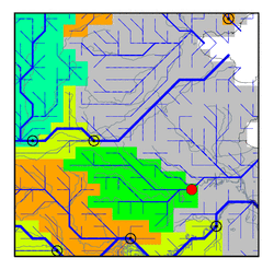
| Station Name (GRDC ID): | Bengbu (2181950) | Basin Name: | Huai |
|---|---|---|---|
| River Name: | Huaihe | Next Downstream Station: | None |
| GRDC Country Code: | CI | Distance to Next Downstream Station: | N.A. |
| Start Year [Month]: | 1915 [7] | Upstream Station(s): | None |
| End Year [Month]: | 1986 [12] | ||
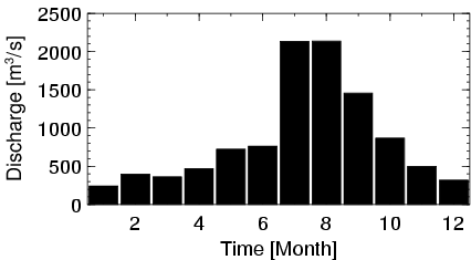
| Mean Discharge: | 864 m3/s | ||
| Minimum Discharge: | 0 m3/s | ||
| Maximum Discharge: | 8690 m3/s | Length of Upstream Mainstem: | 524 km |
| Mean Interstation Discharge: | 864 m3/s | Distance to Basin Outlet: | 403 km |
| GRDC Catchment Area: | 121330 km2 | STN Catchment Area: | 116778 km2 |
| GRDC Interstation Area: | 121330 km2 | STN Interstation Area: | 116778 km2 |
| GRDC Station Runoff: | 224 mm/yr | STN Station Runoff: | 233 mm/yr |
| GRDC Interstation Runoff: | 224 mm/yr | STN Interstation Runoff: | 233 mm/yr |
| Station Field Descriptions | Basin Field Descriptions | ||
| Download | |
|---|---|
| Site Descriptor Information | Station Time Series Data |
| Hydrograph | Station Data | ||||||||||||||||||||||||||||||||||||||||||||||||||||||||
|---|---|---|---|---|---|---|---|---|---|---|---|---|---|---|---|---|---|---|---|---|---|---|---|---|---|---|---|---|---|---|---|---|---|---|---|---|---|---|---|---|---|---|---|---|---|---|---|---|---|---|---|---|---|---|---|---|---|
|
| ||||||||||||||||||||||||||||||||||||||||||||||||||||||||
