 |
 |
|
|
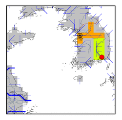
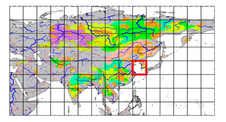
| Station Name (GRDC ID): | Samnangjin (2694510) | Basin Name: | Nag Dong |
|---|---|---|---|
| River Name: | Nagdong | Next Downstream Station: | None |
| GRDC Country Code: | KO | Distance to Next Downstream Station: | N.A. |
| Start Year [Month]: | 1953 [1] | Upstream Station(s): | None |
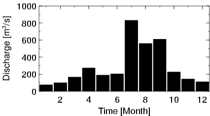
| End Year [Month]: | 1972 [12] | ||
| Mean Discharge: | 290 m3/s | ||
| Minimum Discharge: | 20 m3/s | ||
| Maximum Discharge: | 1700 m3/s | Length of Upstream Mainstem: | 271 km |
| Mean Interstation Discharge: | 290 m3/s | Distance to Basin Outlet: | 72 km |
| GRDC Catchment Area: | 22916 km2 | STN Catchment Area: | 20006 km2 |
| GRDC Interstation Area: | 22916 km2 | STN Interstation Area: | 20006 km2 |
| GRDC Station Runoff: | 399 mm/yr | STN Station Runoff: | 457 mm/yr |
| GRDC Interstation Runoff: | 399 mm/yr | STN Interstation Runoff: | 457 mm/yr |
| Station Field Descriptions | Basin Field Descriptions | ||
| Download | |
|---|---|
| Site Descriptor Information | Station Time Series Data |
| Hydrograph | Station Data | ||||||||||||||||||||||||||||||||||||||||||||||||||||||||
|---|---|---|---|---|---|---|---|---|---|---|---|---|---|---|---|---|---|---|---|---|---|---|---|---|---|---|---|---|---|---|---|---|---|---|---|---|---|---|---|---|---|---|---|---|---|---|---|---|---|---|---|---|---|---|---|---|---|
|
| ||||||||||||||||||||||||||||||||||||||||||||||||||||||||
