 |
 |
|
|
| Station Name (GRDC ID): | Mathanguri (2851250) | Basin Name: | Ganges |
|---|---|---|---|
| River Name: | Manas | Next Downstream Station: | Bahadurabad (2651100) |
| GRDC Country Code: | IN | Distance to Next Downstream Station: | 291 km |
| Start Year [Month]: | 1955 [2] | Upstream Station(s): | None |
| End Year [Month]: | 1974 [12] | ||
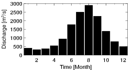
| Mean Discharge: | 1224 m3/s | ||
| Minimum Discharge: | 206 m3/s | ||
| Maximum Discharge: | 7030 m3/s | Length of Upstream Mainstem: | 334 km |
| Mean Interstation Discharge: | 1224 m3/s | Distance to Basin Outlet: | 629 km |
| GRDC Catchment Area: | 32770 km2 | STN Catchment Area: | 32764 km2 |
| GRDC Interstation Area: | 32770 km2 | STN Interstation Area: | 32764 km2 |
| GRDC Station Runoff: | 1178 mm/yr | STN Station Runoff: | 1178 mm/yr |
| GRDC Interstation Runoff: | 1178 mm/yr | STN Interstation Runoff: | 1178 mm/yr |
| Station Field Descriptions | Basin Field Descriptions | ||
| Download | |
|---|---|
| Site Descriptor Information | Station Time Series Data |
| Hydrograph | Station Data | ||||||||||||||||||||||||||||||||||||||||||||||||||||||||
|---|---|---|---|---|---|---|---|---|---|---|---|---|---|---|---|---|---|---|---|---|---|---|---|---|---|---|---|---|---|---|---|---|---|---|---|---|---|---|---|---|---|---|---|---|---|---|---|---|---|---|---|---|---|---|---|---|---|
|
| ||||||||||||||||||||||||||||||||||||||||||||||||||||||||
