 |
 |
|
|
| Station Name (GRDC ID): | Jamtara (2853500) | Basin Name: | Narmada |
|---|---|---|---|
| River Name: | Narmada | Next Downstream Station: | Garudeshwar (2853200) |
| GRDC Country Code: | IN | Distance to Next Downstream Station: | 637 km |
| Start Year [Month]: | 1949 [1] | Upstream Station(s): | None |
| End Year [Month]: | 1974 [12] | ||
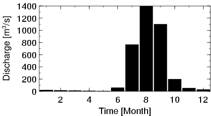
| Mean Discharge: | 304 m3/s | ||
| Minimum Discharge: | 1 m3/s | ||
| Maximum Discharge: | 7704 m3/s | Length of Upstream Mainstem: | 229 km |
| Mean Interstation Discharge: | 304 m3/s | Distance to Basin Outlet: | 944 km |
| GRDC Catchment Area: | 16576 km2 | STN Catchment Area: | 17084 km2 |
| GRDC Interstation Area: | 16576 km2 | STN Interstation Area: | 17084 km2 |
| GRDC Station Runoff: | 578 mm/yr | STN Station Runoff: | 561 mm/yr |
| GRDC Interstation Runoff: | 578 mm/yr | STN Interstation Runoff: | 561 mm/yr |
| Station Field Descriptions | Basin Field Descriptions | ||
| Download | |
|---|---|
| Site Descriptor Information | Station Time Series Data |
| Hydrograph | Station Data | ||||||||||||||||||||||||||||||||||||||||||||||||||||||||
|---|---|---|---|---|---|---|---|---|---|---|---|---|---|---|---|---|---|---|---|---|---|---|---|---|---|---|---|---|---|---|---|---|---|---|---|---|---|---|---|---|---|---|---|---|---|---|---|---|---|---|---|---|---|---|---|---|---|
|
| ||||||||||||||||||||||||||||||||||||||||||||||||||||||||
