 |
 |
|
|
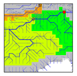
| Station Name (GRDC ID): | Kolymskaya (2998510) | Basin Name: | Kolyma |
|---|---|---|---|
| River Name: | Kolyma | Next Downstream Station: | None |
| GRDC Country Code: | RS | Distance to Next Downstream Station: | N.A. |
| Start Year [Month]: | 1978 [1] | Upstream Station(s): | Sredne-Kolymsk (2998500) |
| End Year [Month]: | 1994 [12] | ||
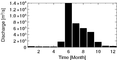
| Mean Discharge: | 3109 m3/s | ||
| Minimum Discharge: | 29 m3/s | ||
| Maximum Discharge: | 25372 m3/s | Length of Upstream Mainstem: | 1899 km |
| Mean Interstation Discharge: | 894 m3/s | Distance to Basin Outlet: | 212 km |
| GRDC Catchment Area: | 526000 km2 | STN Catchment Area: | 536288 km2 |
| GRDC Interstation Area: | 165000 km2 | STN Interstation Area: | 173497 km2 |
| GRDC Station Runoff: | 186 mm/yr | STN Station Runoff: | 183 mm/yr |
| GRDC Interstation Runoff: | 171 mm/yr | STN Interstation Runoff: | 163 mm/yr |
| Station Field Descriptions | Basin Field Descriptions | ||
| Download | |
|---|---|
| Site Descriptor Information | Station Time Series Data |
| Hydrograph | Station Data | ||||||||||||||||||||||||||||||||||||||||||||||||||||||||
|---|---|---|---|---|---|---|---|---|---|---|---|---|---|---|---|---|---|---|---|---|---|---|---|---|---|---|---|---|---|---|---|---|---|---|---|---|---|---|---|---|---|---|---|---|---|---|---|---|---|---|---|---|---|---|---|---|---|
|
| ||||||||||||||||||||||||||||||||||||||||||||||||||||||||
