 |
 |
|
|
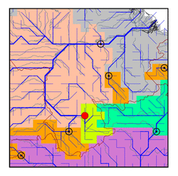
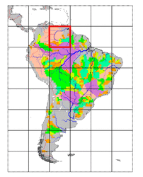
| Station Name (GRDC ID): | Tama-Tama (3206800) | Basin Name: | Orinoco |
|---|---|---|---|
| River Name: | Orinoco | Next Downstream Station: | Puente Angostura (3206720) |
| GRDC Country Code: | VN | Distance to Next Downstream Station: | 1001 km |
| Start Year [Month]: | 1978 [1] | Upstream Station(s): | None |
| End Year [Month]: | 1988 [12] | ||
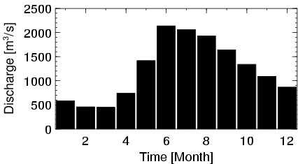
| Mean Discharge: | 1227 m3/s | ||
| Minimum Discharge: | 192 m3/s | ||
| Maximum Discharge: | 2818 m3/s | Length of Upstream Mainstem: | 333 km |
| Mean Interstation Discharge: | 1227 m3/s | Distance to Basin Outlet: | 1456 km |
| GRDC Catchment Area: | 37870 km2 | STN Catchment Area: | 40139 km2 |
| GRDC Interstation Area: | 37870 km2 | STN Interstation Area: | 40139 km2 |
| GRDC Station Runoff: | 1022 mm/yr | STN Station Runoff: | 964 mm/yr |
| GRDC Interstation Runoff: | 1022 mm/yr | STN Interstation Runoff: | 964 mm/yr |
| Station Field Descriptions | Basin Field Descriptions | ||
| Download | |
|---|---|
| Site Descriptor Information | Station Time Series Data |
| Hydrograph | Station Data | ||||||||||||||||||||||||||||||||||||||||||||||||||||||||
|---|---|---|---|---|---|---|---|---|---|---|---|---|---|---|---|---|---|---|---|---|---|---|---|---|---|---|---|---|---|---|---|---|---|---|---|---|---|---|---|---|---|---|---|---|---|---|---|---|---|---|---|---|---|---|---|---|---|
|
| ||||||||||||||||||||||||||||||||||||||||||||||||||||||||
