 |
 |
|
|
| Station Name (GRDC ID): | el Sauce (1967: Embalse Rio Hondo) (3274150) | Basin Name: | Noname (GHAASBasin174) |
|---|---|---|---|
| River Name: | Dulce | Next Downstream Station: | None |
| GRDC Country Code: | AG | Distance to Next Downstream Station: | N.A. |
| Start Year [Month]: | 1926 [9] | Upstream Station(s): | None |
| End Year [Month]: | 1980 [4] | ||
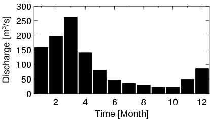
| Mean Discharge: | 94 m3/s | ||
| Minimum Discharge: | 0 m3/s | ||
| Maximum Discharge: | 1999 m3/s | Length of Upstream Mainstem: | 260 km |
| Mean Interstation Discharge: | 94 m3/s | Distance to Basin Outlet: | 638 km |
| GRDC Catchment Area: | 20200 km2 | STN Catchment Area: | 22071 km2 |
| GRDC Interstation Area: | 20200 km2 | STN Interstation Area: | 22071 km2 |
| GRDC Station Runoff: | 147 mm/yr | STN Station Runoff: | 135 mm/yr |
| GRDC Interstation Runoff: | 147 mm/yr | STN Interstation Runoff: | 135 mm/yr |
| Station Field Descriptions | Basin Field Descriptions | ||
| Download | |
|---|---|
| Site Descriptor Information | Station Time Series Data |
| Hydrograph | Station Data | ||||||||||||||||||||||||||||||||||||||||||||||||||||||||
|---|---|---|---|---|---|---|---|---|---|---|---|---|---|---|---|---|---|---|---|---|---|---|---|---|---|---|---|---|---|---|---|---|---|---|---|---|---|---|---|---|---|---|---|---|---|---|---|---|---|---|---|---|---|---|---|---|---|
|
| ||||||||||||||||||||||||||||||||||||||||||||||||||||||||
