 |
 |
|
|
| Station Name (GRDC ID): | la Puntilla (3275100) | Basin Name: | Colorado (Arg) |
|---|---|---|---|
| River Name: | San Juan | Next Downstream Station: | None |
| GRDC Country Code: | AG | Distance to Next Downstream Station: | N.A. |
| Start Year [Month]: | 1909 [7] | Upstream Station(s): | None |
| End Year [Month]: | 1980 [5] | ||
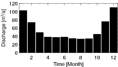
| Mean Discharge: | 56 m3/s | ||
| Minimum Discharge: | 3 m3/s | ||
| Maximum Discharge: | 669 m3/s | Length of Upstream Mainstem: | 249 km |
| Mean Interstation Discharge: | 56 m3/s | Distance to Basin Outlet: | 1351 km |
| GRDC Catchment Area: | 25000 km2 | STN Catchment Area: | 26356 km2 |
| GRDC Interstation Area: | 25000 km2 | STN Interstation Area: | 26356 km2 |
| GRDC Station Runoff: | 71 mm/yr | STN Station Runoff: | 67 mm/yr |
| GRDC Interstation Runoff: | 71 mm/yr | STN Interstation Runoff: | 67 mm/yr |
| Station Field Descriptions | Basin Field Descriptions | ||
| Download | |
|---|---|
| Site Descriptor Information | Station Time Series Data |
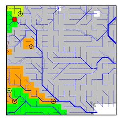
| Hydrograph | Station Data | ||||||||||||||||||||||||||||||||||||||||||||||||||||||||
|---|---|---|---|---|---|---|---|---|---|---|---|---|---|---|---|---|---|---|---|---|---|---|---|---|---|---|---|---|---|---|---|---|---|---|---|---|---|---|---|---|---|---|---|---|---|---|---|---|---|---|---|---|---|---|---|---|---|
|
| ||||||||||||||||||||||||||||||||||||||||||||||||||||||||
