 |
 |
|
|
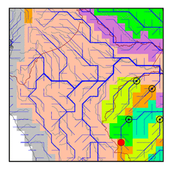
| Station Name (GRDC ID): | Taumaturgo (3624180) | Basin Name: | Amazon |
|---|---|---|---|
| River Name: | Rio Jurua | Next Downstream Station: | Cruzeiro do Sul (3624160) |
| GRDC Country Code: | BZ | Distance to Next Downstream Station: | 189 km |
| Start Year [Month]: | 1981 [5] | Upstream Station(s): | None |
| End Year [Month]: | 1993 [3] | ||
| Mean Discharge: | 412 m3/s | ||
| Minimum Discharge: | 5 m3/s | ||
| Maximum Discharge: | 1511 m3/s | Length of Upstream Mainstem: | 245 km |
| Mean Interstation Discharge: | 412 m3/s | Distance to Basin Outlet: | 3022 km |
| GRDC Catchment Area: | 16581 km2 | STN Catchment Area: | 15246 km2 |
| GRDC Interstation Area: | 16581 km2 | STN Interstation Area: | 15246 km2 |
| GRDC Station Runoff: | 784 mm/yr | STN Station Runoff: | 852 mm/yr |
| GRDC Interstation Runoff: | 784 mm/yr | STN Interstation Runoff: | 852 mm/yr |
| Station Field Descriptions | Basin Field Descriptions | ||
| Download | |
|---|---|
| Site Descriptor Information | Station Time Series Data |
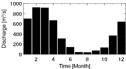
| Hydrograph | Station Data | ||||||||||||||||||||||||||||||||||||||||||||||||||||||||
|---|---|---|---|---|---|---|---|---|---|---|---|---|---|---|---|---|---|---|---|---|---|---|---|---|---|---|---|---|---|---|---|---|---|---|---|---|---|---|---|---|---|---|---|---|---|---|---|---|---|---|---|---|---|---|---|---|---|
|
| ||||||||||||||||||||||||||||||||||||||||||||||||||||||||
