 |
 |
|
|
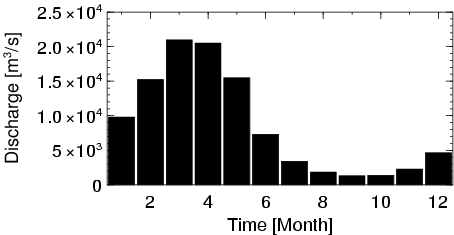
| Station Name (GRDC ID): | Altamira (3630050) | Basin Name: | Amazon |
|---|---|---|---|
| River Name: | Xingu | Next Downstream Station: | None |
| GRDC Country Code: | BZ | Distance to Next Downstream Station: | N.A. |
| Start Year [Month]: | 1971 [4] | Upstream Station(s): | Pedra do o (3630120) |
| End Year [Month]: | 1995 [1] | ||
| Mean Discharge: | 8670 m3/s | ||
| Minimum Discharge: | 808 m3/s | ||
| Maximum Discharge: | 32298 m3/s | Length of Upstream Mainstem: | 1579 km |
| Mean Interstation Discharge: | 6055 m3/s | Distance to Basin Outlet: | 481 km |
| GRDC Catchment Area: | 446570 km2 | STN Catchment Area: | 448086 km2 |
| GRDC Interstation Area: | 322743 km2 | STN Interstation Area: | 322365 km2 |
| GRDC Station Runoff: | 612 mm/yr | STN Station Runoff: | 610 mm/yr |
| GRDC Interstation Runoff: | 592 mm/yr | STN Interstation Runoff: | 592 mm/yr |
| Station Field Descriptions | Basin Field Descriptions | ||
| Download | |
|---|---|
| Site Descriptor Information | Station Time Series Data |
| Hydrograph | Station Data | ||||||||||||||||||||||||||||||||||||||||||||||||||||||||
|---|---|---|---|---|---|---|---|---|---|---|---|---|---|---|---|---|---|---|---|---|---|---|---|---|---|---|---|---|---|---|---|---|---|---|---|---|---|---|---|---|---|---|---|---|---|---|---|---|---|---|---|---|---|---|---|---|---|
|
| ||||||||||||||||||||||||||||||||||||||||||||||||||||||||
