 |
 |
|
|
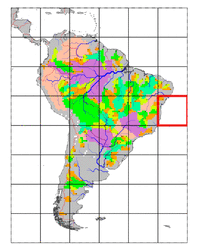
| Station Name (GRDC ID): | Jequie (3652220) | Basin Name: | GHAASBasin308 |
|---|---|---|---|
| River Name: | Rio Contas | Next Downstream Station: | None |
| GRDC Country Code: | BZ | Distance to Next Downstream Station: | N.A. |
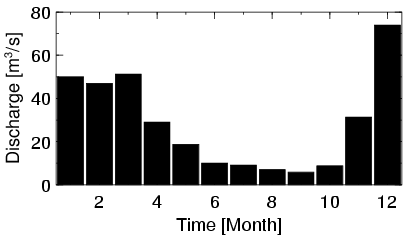
| Start Year [Month]: | 1934 [5] | Upstream Station(s): | None |
| End Year [Month]: | 1977 [12] | ||
| Mean Discharge: | 29 m3/s | ||
| Minimum Discharge: | 0 m3/s | ||
| Maximum Discharge: | 614 m3/s | Length of Upstream Mainstem: | 396 km |
| Mean Interstation Discharge: | 29 m3/s | Distance to Basin Outlet: | 108 km |
| GRDC Catchment Area: | 42245 km2 | STN Catchment Area: | 44968 km2 |
| GRDC Interstation Area: | 42245 km2 | STN Interstation Area: | 44968 km2 |
| GRDC Station Runoff: | 21 mm/yr | STN Station Runoff: | 20 mm/yr |
| GRDC Interstation Runoff: | 21 mm/yr | STN Interstation Runoff: | 20 mm/yr |
| Station Field Descriptions | Basin Field Descriptions | ||
| Download | |
|---|---|
| Site Descriptor Information | Station Time Series Data |
| Hydrograph | Station Data | ||||||||||||||||||||||||||||||||||||||||||||||||||||||||
|---|---|---|---|---|---|---|---|---|---|---|---|---|---|---|---|---|---|---|---|---|---|---|---|---|---|---|---|---|---|---|---|---|---|---|---|---|---|---|---|---|---|---|---|---|---|---|---|---|---|---|---|---|---|---|---|---|---|
|
| ||||||||||||||||||||||||||||||||||||||||||||||||||||||||
