 |
 |
|
|
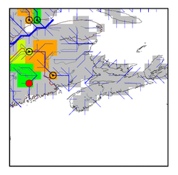
| Station Name (GRDC ID): | West Enfield, Me. (4147010) | Basin Name: | Penobscot |
|---|---|---|---|
| River Name: | Penobscot | Next Downstream Station: | None |
| GRDC Country Code: | US | Distance to Next Downstream Station: | N.A. |
| Start Year [Month]: | 1902 [1] | Upstream Station(s): | None |
| End Year [Month]: | 1984 [3] | ||
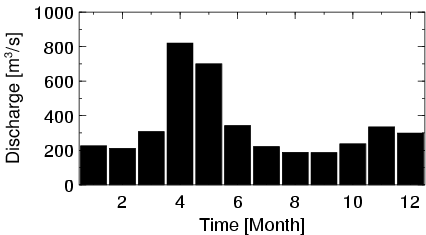
| Mean Discharge: | 340 m3/s | ||
| Minimum Discharge: | 50 m3/s | ||
| Maximum Discharge: | 1415 m3/s | Length of Upstream Mainstem: | 269 km |
| Mean Interstation Discharge: | 340 m3/s | Distance to Basin Outlet: | 111 km |
| GRDC Catchment Area: | 17275 km2 | STN Catchment Area: | 17237 km2 |
| GRDC Interstation Area: | 17275 km2 | STN Interstation Area: | 17237 km2 |
| GRDC Station Runoff: | 620 mm/yr | STN Station Runoff: | 621 mm/yr |
| GRDC Interstation Runoff: | 620 mm/yr | STN Interstation Runoff: | 621 mm/yr |
| Station Field Descriptions | Basin Field Descriptions | ||
| Download | |
|---|---|
| Site Descriptor Information | Station Time Series Data |
| Hydrograph | Station Data | ||||||||||||||||||||||||||||||||||||||||||||||||||||||||
|---|---|---|---|---|---|---|---|---|---|---|---|---|---|---|---|---|---|---|---|---|---|---|---|---|---|---|---|---|---|---|---|---|---|---|---|---|---|---|---|---|---|---|---|---|---|---|---|---|---|---|---|---|---|---|---|---|---|
|
| ||||||||||||||||||||||||||||||||||||||||||||||||||||||||
