 |
 |
|
|
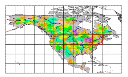
| Station Name (GRDC ID): | Thompsonville, Conn. (4147460) | Basin Name: | Connecticut |
|---|---|---|---|
| River Name: | Connecticut | Next Downstream Station: | None |
| GRDC Country Code: | US | Distance to Next Downstream Station: | N.A. |
| Start Year [Month]: | 1928 [8] | Upstream Station(s): | None |
| End Year [Month]: | 1984 [9] | ||
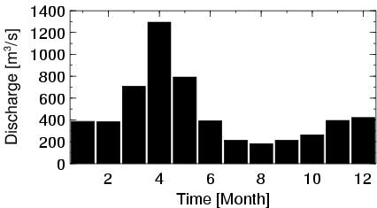
| Mean Discharge: | 470 m3/s | ||
| Minimum Discharge: | 76 m3/s | ||
| Maximum Discharge: | 2525 m3/s | Length of Upstream Mainstem: | 428 km |
| Mean Interstation Discharge: | 470 m3/s | Distance to Basin Outlet: | 125 km |
| GRDC Catchment Area: | 25022 km2 | STN Catchment Area: | 22383 km2 |
| GRDC Interstation Area: | 25022 km2 | STN Interstation Area: | 22383 km2 |
| GRDC Station Runoff: | 593 mm/yr | STN Station Runoff: | 662 mm/yr |
| GRDC Interstation Runoff: | 593 mm/yr | STN Interstation Runoff: | 662 mm/yr |
| Station Field Descriptions | Basin Field Descriptions | ||
| Download | |
|---|---|
| Site Descriptor Information | Station Time Series Data |
| Hydrograph | Station Data | ||||||||||||||||||||||||||||||||||||||||||||||||||||||||
|---|---|---|---|---|---|---|---|---|---|---|---|---|---|---|---|---|---|---|---|---|---|---|---|---|---|---|---|---|---|---|---|---|---|---|---|---|---|---|---|---|---|---|---|---|---|---|---|---|---|---|---|---|---|---|---|---|---|
|
| ||||||||||||||||||||||||||||||||||||||||||||||||||||||||
