 |
 |
|
|
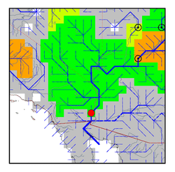
| Station Name (GRDC ID): | Yuma, Ariz. (4152100) | Basin Name: | Colorado (Ari) |
|---|---|---|---|
| River Name: | Colorado | Next Downstream Station: | None |
| GRDC Country Code: | US | Distance to Next Downstream Station: | N.A. |
| Start Year [Month]: | 1965 [1] | Upstream Station(s): | Lees Ferry, Ariz. (4152450) |
| End Year [Month]: | 1975 [12] | ||
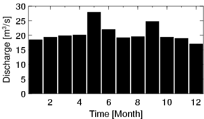
| Mean Discharge: | 21 m3/s | ||
| Minimum Discharge: | 8 m3/s | ||
| Maximum Discharge: | 46 m3/s | Length of Upstream Mainstem: | 1589 km |
| Mean Interstation Discharge: | -443 m3/s | Distance to Basin Outlet: | 274 km |
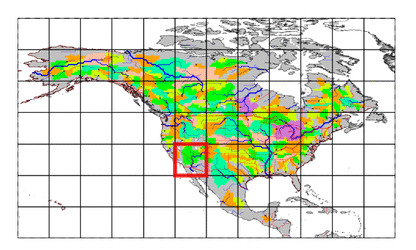
| GRDC Catchment Area: | 629100 km2 | STN Catchment Area: | 608155 km2 |
| GRDC Interstation Area: | 339538 km2 | STN Interstation Area: | 324612 km2 |
| GRDC Station Runoff: | 1 mm/yr | STN Station Runoff: | 1 mm/yr |
| GRDC Interstation Runoff: | -41 mm/yr | STN Interstation Runoff: | -43 mm/yr |
| Station Field Descriptions | Basin Field Descriptions | ||
| Download | |
|---|---|
| Site Descriptor Information | Station Time Series Data |
| Hydrograph | Station Data | ||||||||||||||||||||||||||||||||||||||||||||||||||||||||
|---|---|---|---|---|---|---|---|---|---|---|---|---|---|---|---|---|---|---|---|---|---|---|---|---|---|---|---|---|---|---|---|---|---|---|---|---|---|---|---|---|---|---|---|---|---|---|---|---|---|---|---|---|---|---|---|---|---|
|
| ||||||||||||||||||||||||||||||||||||||||||||||||||||||||
