 |
 |
|
|
| Station Name (GRDC ID): | Mayo (4203150) | Basin Name: | Yukon |
|---|---|---|---|
| River Name: | Stewart River | Next Downstream Station: | Dawson (4203200) |
| GRDC Country Code: | CN | Distance to Next Downstream Station: | 404 km |
| Start Year [Month]: | 1949 [1] | Upstream Station(s): | None |
| End Year [Month]: | 1964 [9] | ||
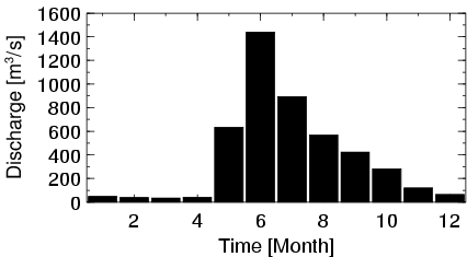
| Mean Discharge: | 382 m3/s | ||
| Minimum Discharge: | 20 m3/s | ||
| Maximum Discharge: | 2929 m3/s | Length of Upstream Mainstem: | 383 km |
| Mean Interstation Discharge: | 382 m3/s | Distance to Basin Outlet: | 2314 km |
| GRDC Catchment Area: | 31598 km2 | STN Catchment Area: | 34470 km2 |
| GRDC Interstation Area: | 31598 km2 | STN Interstation Area: | 34470 km2 |
| GRDC Station Runoff: | 381 mm/yr | STN Station Runoff: | 350 mm/yr |
| GRDC Interstation Runoff: | 381 mm/yr | STN Interstation Runoff: | 350 mm/yr |
| Station Field Descriptions | Basin Field Descriptions | ||
| Download | |
|---|---|
| Site Descriptor Information | Station Time Series Data |
| Hydrograph | Station Data | ||||||||||||||||||||||||||||||||||||||||||||||||||||||||
|---|---|---|---|---|---|---|---|---|---|---|---|---|---|---|---|---|---|---|---|---|---|---|---|---|---|---|---|---|---|---|---|---|---|---|---|---|---|---|---|---|---|---|---|---|---|---|---|---|---|---|---|---|---|---|---|---|---|
|
| ||||||||||||||||||||||||||||||||||||||||||||||||||||||||
