 |
 |
|
|
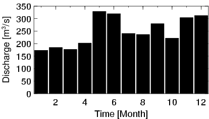
| Station Name (GRDC ID): | Szczucin (6458450) | Basin Name: | Wisla |
|---|---|---|---|
| River Name: | Wisla | Next Downstream Station: | Warszawa (6458500) |
| GRDC Country Code: | PL | Distance to Next Downstream Station: | 278 km |
| Start Year [Month]: | 1921 [1] | Upstream Station(s): | None |
| End Year [Month]: | 1990 [12] | ||
| Mean Discharge: | 248 m3/s | ||
| Minimum Discharge: | 8 m3/s | ||
| Maximum Discharge: | 9999 m3/s | Length of Upstream Mainstem: | 208 km |
| Mean Interstation Discharge: | 248 m3/s | Distance to Basin Outlet: | 728 km |
| GRDC Catchment Area: | 23901 km2 | STN Catchment Area: | 27797 km2 |
| GRDC Interstation Area: | 23901 km2 | STN Interstation Area: | 27797 km2 |
| GRDC Station Runoff: | 327 mm/yr | STN Station Runoff: | 281 mm/yr |
| GRDC Interstation Runoff: | 327 mm/yr | STN Interstation Runoff: | 281 mm/yr |
| Station Field Descriptions | Basin Field Descriptions | ||
| Download | |
|---|---|
| Site Descriptor Information | Station Time Series Data |
| Hydrograph | Station Data | ||||||||||||||||||||||||||||||||||||||||||||||||||||||||
|---|---|---|---|---|---|---|---|---|---|---|---|---|---|---|---|---|---|---|---|---|---|---|---|---|---|---|---|---|---|---|---|---|---|---|---|---|---|---|---|---|---|---|---|---|---|---|---|---|---|---|---|---|---|---|---|---|---|
|
| ||||||||||||||||||||||||||||||||||||||||||||||||||||||||
