 |
 |
|
|
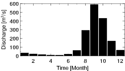
| Station Name (GRDC ID): | Dioila (1134200) | Basin Name: | Niger |
|---|---|---|---|
| River Name: | Baoule | Next Downstream Station: | Douna (1134300) |
| GRDC Country Code: | MI | Distance to Next Downstream Station: | 186 km |
| Start Year [Month]: | 1953 [6] | Upstream Station(s): | Bougouni (1134110) |
| End Year [Month]: | 1990 [12] | ||
| Mean Discharge: | 143 m3/s | ||
| Minimum Discharge: | 0 m3/s | ||
| Maximum Discharge: | 1440 m3/s | Length of Upstream Mainstem: | 456 km |
| Mean Interstation Discharge: | 42 m3/s | Distance to Basin Outlet: | 2794 km |
| GRDC Catchment Area: | 32500 km2 | STN Catchment Area: | 33336 km2 |
| GRDC Interstation Area: | 16800 km2 | STN Interstation Area: | 18142 km2 |
| GRDC Station Runoff: | 139 mm/yr | STN Station Runoff: | 136 mm/yr |
| GRDC Interstation Runoff: | 79 mm/yr | STN Interstation Runoff: | 73 mm/yr |
| Station Field Descriptions | Basin Field Descriptions | ||
| Download | |
|---|---|
| Site Descriptor Information | Station Time Series Data |
| Hydrograph | Station Data | ||||||||||||||||||||||||||||||||||||||||||||||||||||||||
|---|---|---|---|---|---|---|---|---|---|---|---|---|---|---|---|---|---|---|---|---|---|---|---|---|---|---|---|---|---|---|---|---|---|---|---|---|---|---|---|---|---|---|---|---|---|---|---|---|---|---|---|---|---|---|---|---|---|
|
| ||||||||||||||||||||||||||||||||||||||||||||||||||||||||
