 |
 |
|
|
| Station Name (GRDC ID): | Douna (1134300) | Basin Name: | Niger |
|---|---|---|---|
| River Name: | Bani | Next Downstream Station: | Mopti (1134500) |
| GRDC Country Code: | MI | Distance to Next Downstream Station: | 155 km |
| Start Year [Month]: | 1922 [5] | Upstream Station(s): | Dioila (1134200) Pankourou (1134220) |
| End Year [Month]: | 1994 [12] | ||
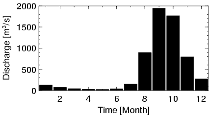
| Mean Discharge: | 513 m3/s | ||
| Minimum Discharge: | 0 m3/s | ||
| Maximum Discharge: | 4090 m3/s | Length of Upstream Mainstem: | 620 km |
| Mean Interstation Discharge: | 199 m3/s | Distance to Basin Outlet: | 2608 km |
| GRDC Catchment Area: | 101600 km2 | STN Catchment Area: | 102981 km2 |
| GRDC Interstation Area: | 37300 km2 | STN Interstation Area: | 36214 km2 |
| GRDC Station Runoff: | 159 mm/yr | STN Station Runoff: | 157 mm/yr |
| GRDC Interstation Runoff: | 169 mm/yr | STN Interstation Runoff: | 174 mm/yr |
| Station Field Descriptions | Basin Field Descriptions | ||
| Download | |
|---|---|
| Site Descriptor Information | Station Time Series Data |
| Hydrograph | Station Data | ||||||||||||||||||||||||||||||||||||||||||||||||||||||||
|---|---|---|---|---|---|---|---|---|---|---|---|---|---|---|---|---|---|---|---|---|---|---|---|---|---|---|---|---|---|---|---|---|---|---|---|---|---|---|---|---|---|---|---|---|---|---|---|---|---|---|---|---|---|---|---|---|---|
|
| ||||||||||||||||||||||||||||||||||||||||||||||||||||||||
