 |
 |
|
|
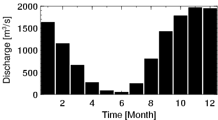
| Station Name (GRDC ID): | Dire (1134700) | Basin Name: | Niger |
|---|---|---|---|
| River Name: | Niger | Next Downstream Station: | Ansongo (1134900) |
| GRDC Country Code: | MI | Distance to Next Downstream Station: | 600 km |
| Start Year [Month]: | 1924 [1] | Upstream Station(s): | Mopti (1134500) |
| End Year [Month]: | 1992 [12] | ||
| Mean Discharge: | 1003 m3/s | ||
| Minimum Discharge: | 0 m3/s | ||
| Maximum Discharge: | 2638 m3/s | Length of Upstream Mainstem: | 1214 km |
| Mean Interstation Discharge: | -97 m3/s | Distance to Basin Outlet: | 2264 km |
| GRDC Catchment Area: | 340000 km2 | STN Catchment Area: | 367900 km2 |
| GRDC Interstation Area: | 58400 km2 | STN Interstation Area: | 59715 km2 |
| GRDC Station Runoff: | 93 mm/yr | STN Station Runoff: | 86 mm/yr |
| GRDC Interstation Runoff: | -53 mm/yr | STN Interstation Runoff: | -51 mm/yr |
| Station Field Descriptions | Basin Field Descriptions | ||
| Download | |
|---|---|
| Site Descriptor Information | Station Time Series Data |
| Hydrograph | Station Data | ||||||||||||||||||||||||||||||||||||||||||||||||||||||||
|---|---|---|---|---|---|---|---|---|---|---|---|---|---|---|---|---|---|---|---|---|---|---|---|---|---|---|---|---|---|---|---|---|---|---|---|---|---|---|---|---|---|---|---|---|---|---|---|---|---|---|---|---|---|---|---|---|---|
|
| ||||||||||||||||||||||||||||||||||||||||||||||||||||||||
