 |
 |
|
|
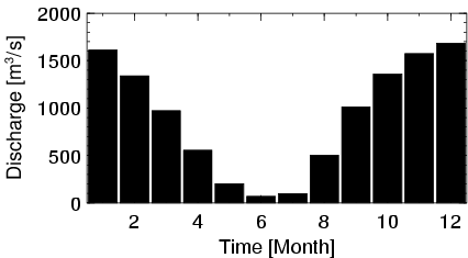
| Station Name (GRDC ID): | Ansongo (1134900) | Basin Name: | Niger |
|---|---|---|---|
| River Name: | Niger | Next Downstream Station: | Niamey (1234150) |
| GRDC Country Code: | MI | Distance to Next Downstream Station: | 320 km |
| Start Year [Month]: | 1951 [1] | Upstream Station(s): | Dire (1134700) |
| End Year [Month]: | 1992 [12] | ||
| Mean Discharge: | 915 m3/s | ||
| Minimum Discharge: | 5 m3/s | ||
| Maximum Discharge: | 2230 m3/s | Length of Upstream Mainstem: | 1814 km |
| Mean Interstation Discharge: | -88 m3/s | Distance to Basin Outlet: | 1664 km |
| GRDC Catchment Area: | 566000 km2 | STN Catchment Area: | 647527 km2 |
| GRDC Interstation Area: | 226000 km2 | STN Interstation Area: | 279627 km2 |
| GRDC Station Runoff: | 51 mm/yr | STN Station Runoff: | 45 mm/yr |
| GRDC Interstation Runoff: | -12 mm/yr | STN Interstation Runoff: | -10 mm/yr |
| Station Field Descriptions | Basin Field Descriptions | ||
| Download | |
|---|---|
| Site Descriptor Information | Station Time Series Data |
| Hydrograph | Station Data | ||||||||||||||||||||||||||||||||||||||||||||||||||||||||
|---|---|---|---|---|---|---|---|---|---|---|---|---|---|---|---|---|---|---|---|---|---|---|---|---|---|---|---|---|---|---|---|---|---|---|---|---|---|---|---|---|---|---|---|---|---|---|---|---|---|---|---|---|---|---|---|---|---|
|
| ||||||||||||||||||||||||||||||||||||||||||||||||||||||||
