 |
 |
|
|
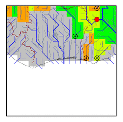
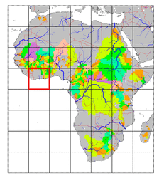
| Station Name (GRDC ID): | Bamboi (1531100) | Basin Name: | Volta |
|---|---|---|---|
| River Name: | Black Volta | Next Downstream Station: | Senchi(Halcrow) (1531700) |
| GRDC Country Code: | GH | Distance to Next Downstream Station: | 401 km |
| Start Year [Month]: | 1950 [3] | Upstream Station(s): | Dapola (1931400) |
| End Year [Month]: | 1974 [2] | ||
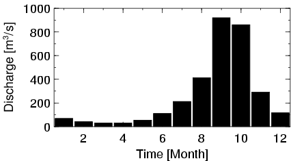
| Mean Discharge: | 263 m3/s | ||
| Minimum Discharge: | 2 m3/s | ||
| Maximum Discharge: | 2320 m3/s | Length of Upstream Mainstem: | 843 km |
| Mean Interstation Discharge: | 162 m3/s | Distance to Basin Outlet: | 512 km |
| GRDC Catchment Area: | 134200 km2 | STN Catchment Area: | 139548 km2 |
| GRDC Interstation Area: | 67660 km2 | STN Interstation Area: | 64050 km2 |
| GRDC Station Runoff: | 62 mm/yr | STN Station Runoff: | 59 mm/yr |
| GRDC Interstation Runoff: | 75 mm/yr | STN Interstation Runoff: | 80 mm/yr |
| Station Field Descriptions | Basin Field Descriptions | ||
| Download | |
|---|---|
| Site Descriptor Information | Station Time Series Data |
| Hydrograph | Station Data | ||||||||||||||||||||||||||||||||||||||||||||||||||||||||
|---|---|---|---|---|---|---|---|---|---|---|---|---|---|---|---|---|---|---|---|---|---|---|---|---|---|---|---|---|---|---|---|---|---|---|---|---|---|---|---|---|---|---|---|---|---|---|---|---|---|---|---|---|---|---|---|---|---|
|
| ||||||||||||||||||||||||||||||||||||||||||||||||||||||||
