 |
 |
|
|
| Station Name (GRDC ID): | Roseires Dam (1663800) | Basin Name: | Nile |
|---|---|---|---|
| River Name: | Blue Nile | Next Downstream Station: | Khartoum (1663100) |
| GRDC Country Code: | SU | Distance to Next Downstream Station: | 399 km |
| Start Year [Month]: | 1912 [1] | Upstream Station(s): | None |
| End Year [Month]: | 1982 [12] | ||
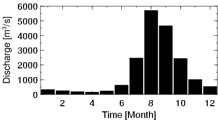
| Mean Discharge: | 1548 m3/s | ||
| Minimum Discharge: | 48 m3/s | ||
| Maximum Discharge: | 9408 m3/s | Length of Upstream Mainstem: | 1207 km |
| Mean Interstation Discharge: | 1548 m3/s | Distance to Basin Outlet: | 3208 km |
| GRDC Catchment Area: | 210000 km2 | STN Catchment Area: | 154992 km2 |
| GRDC Interstation Area: | 210000 km2 | STN Interstation Area: | 154992 km2 |
| GRDC Station Runoff: | 233 mm/yr | STN Station Runoff: | 315 mm/yr |
| GRDC Interstation Runoff: | 233 mm/yr | STN Interstation Runoff: | 315 mm/yr |
| Station Field Descriptions | Basin Field Descriptions | ||
| Download | |
|---|---|
| Site Descriptor Information | Station Time Series Data |
| Hydrograph | Station Data | ||||||||||||||||||||||||||||||||||||||||||||||||||||||||
|---|---|---|---|---|---|---|---|---|---|---|---|---|---|---|---|---|---|---|---|---|---|---|---|---|---|---|---|---|---|---|---|---|---|---|---|---|---|---|---|---|---|---|---|---|---|---|---|---|---|---|---|---|---|---|---|---|---|
|
| ||||||||||||||||||||||||||||||||||||||||||||||||||||||||
