 |
 |
|
|
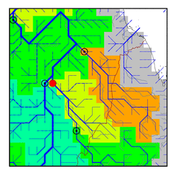
| Station Name (GRDC ID): | Khartoum (1663100) | Basin Name: | Nile |
|---|---|---|---|
| River Name: | Blue Nile | Next Downstream Station: | Dongola (1662100) |
| GRDC Country Code: | SU | Distance to Next Downstream Station: | 1121 km |
| Start Year [Month]: | 1900 [1] | Upstream Station(s): | Roseires Dam (1663800) |
| End Year [Month]: | 1982 [12] | ||
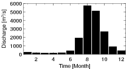
| Mean Discharge: | 1513 m3/s | ||
| Minimum Discharge: | 9 m3/s | ||
| Maximum Discharge: | 8834 m3/s | Length of Upstream Mainstem: | 1606 km |
| Mean Interstation Discharge: | -36 m3/s | Distance to Basin Outlet: | 2809 km |
| GRDC Catchment Area: | 325000 km2 | STN Catchment Area: | 275123 km2 |
| GRDC Interstation Area: | 115000 km2 | STN Interstation Area: | 120132 km2 |
| GRDC Station Runoff: | 147 mm/yr | STN Station Runoff: | 173 mm/yr |
| GRDC Interstation Runoff: | -10 mm/yr | STN Interstation Runoff: | -9 mm/yr |
| Station Field Descriptions | Basin Field Descriptions | ||
| Download | |
|---|---|
| Site Descriptor Information | Station Time Series Data |
| Hydrograph | Station Data | ||||||||||||||||||||||||||||||||||||||||||||||||||||||||
|---|---|---|---|---|---|---|---|---|---|---|---|---|---|---|---|---|---|---|---|---|---|---|---|---|---|---|---|---|---|---|---|---|---|---|---|---|---|---|---|---|---|---|---|---|---|---|---|---|---|---|---|---|---|---|---|---|---|
|
| ||||||||||||||||||||||||||||||||||||||||||||||||||||||||
