 |
 |
|
|
| Station Name (GRDC ID): | Bossangoa (1737150) | Basin Name: | Chari |
|---|---|---|---|
| River Name: | Ouham | Next Downstream Station: | Batangafo (1737210) |
| GRDC Country Code: | CE | Distance to Next Downstream Station: | 157 km |
| Start Year [Month]: | 1951 [5] | Upstream Station(s): | None |
| End Year [Month]: | 1992 [3] | ||
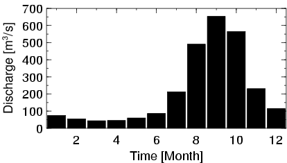
| Mean Discharge: | 219 m3/s | ||
| Minimum Discharge: | 0 m3/s | ||
| Maximum Discharge: | 1110 m3/s | Length of Upstream Mainstem: | 299 km |
| Mean Interstation Discharge: | 219 m3/s | Distance to Basin Outlet: | 1112 km |
| GRDC Catchment Area: | 22800 km2 | STN Catchment Area: | 21519 km2 |
| GRDC Interstation Area: | 22800 km2 | STN Interstation Area: | 21519 km2 |
| GRDC Station Runoff: | 303 mm/yr | STN Station Runoff: | 321 mm/yr |
| GRDC Interstation Runoff: | 303 mm/yr | STN Interstation Runoff: | 321 mm/yr |
| Station Field Descriptions | Basin Field Descriptions | ||
| Download | |
|---|---|
| Site Descriptor Information | Station Time Series Data |
| Hydrograph | Station Data | ||||||||||||||||||||||||||||||||||||||||||||||||||||||||
|---|---|---|---|---|---|---|---|---|---|---|---|---|---|---|---|---|---|---|---|---|---|---|---|---|---|---|---|---|---|---|---|---|---|---|---|---|---|---|---|---|---|---|---|---|---|---|---|---|---|---|---|---|---|---|---|---|---|
|
| ||||||||||||||||||||||||||||||||||||||||||||||||||||||||
