 |
 |
|
|
| Station Name (GRDC ID): | Kembe (1749480) | Basin Name: | Zaire |
|---|---|---|---|
| River Name: | Kotto | Next Downstream Station: | Bangui (1749100) |
| GRDC Country Code: | CE | Distance to Next Downstream Station: | 569 km |
| Start Year [Month]: | 1948 [4] | Upstream Station(s): | None |
| End Year [Month]: | 1973 [3] | ||
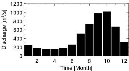
| Mean Discharge: | 447 m3/s | ||
| Minimum Discharge: | 77 m3/s | ||
| Maximum Discharge: | 1460 m3/s | Length of Upstream Mainstem: | 569 km |
| Mean Interstation Discharge: | 447 m3/s | Distance to Basin Outlet: | 2053 km |
| GRDC Catchment Area: | 78400 km2 | STN Catchment Area: | 79767 km2 |
| GRDC Interstation Area: | 78400 km2 | STN Interstation Area: | 79767 km2 |
| GRDC Station Runoff: | 180 mm/yr | STN Station Runoff: | 177 mm/yr |
| GRDC Interstation Runoff: | 180 mm/yr | STN Interstation Runoff: | 177 mm/yr |
| Station Field Descriptions | Basin Field Descriptions | ||
| Download | |
|---|---|
| Site Descriptor Information | Station Time Series Data |
| Hydrograph | Station Data | ||||||||||||||||||||||||||||||||||||||||||||||||||||||||
|---|---|---|---|---|---|---|---|---|---|---|---|---|---|---|---|---|---|---|---|---|---|---|---|---|---|---|---|---|---|---|---|---|---|---|---|---|---|---|---|---|---|---|---|---|---|---|---|---|---|---|---|---|---|---|---|---|---|
|
| ||||||||||||||||||||||||||||||||||||||||||||||||||||||||
