 |
 |
|
|
| Station Name (GRDC ID): | Zemio (1749600) | Basin Name: | Zaire |
|---|---|---|---|
| River Name: | M'bomou | Next Downstream Station: | Rafai (1749550) |
| GRDC Country Code: | CE | Distance to Next Downstream Station: | 55 km |
| Start Year [Month]: | 1952 [8] | Upstream Station(s): | None |
| End Year [Month]: | 1994 [3] | ||
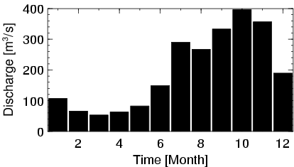
| Mean Discharge: | 196 m3/s | ||
| Minimum Discharge: | 7 m3/s | ||
| Maximum Discharge: | 2220 m3/s | Length of Upstream Mainstem: | 356 km |
| Mean Interstation Discharge: | 196 m3/s | Distance to Basin Outlet: | 2353 km |
| GRDC Catchment Area: | 29300 km2 | STN Catchment Area: | 30785 km2 |
| GRDC Interstation Area: | 29300 km2 | STN Interstation Area: | 30785 km2 |
| GRDC Station Runoff: | 211 mm/yr | STN Station Runoff: | 201 mm/yr |
| GRDC Interstation Runoff: | 211 mm/yr | STN Interstation Runoff: | 201 mm/yr |
| Station Field Descriptions | Basin Field Descriptions | ||
| Download | |
|---|---|
| Site Descriptor Information | Station Time Series Data |
| Hydrograph | Station Data | ||||||||||||||||||||||||||||||||||||||||||||||||||||||||
|---|---|---|---|---|---|---|---|---|---|---|---|---|---|---|---|---|---|---|---|---|---|---|---|---|---|---|---|---|---|---|---|---|---|---|---|---|---|---|---|---|---|---|---|---|---|---|---|---|---|---|---|---|---|---|---|---|---|
|
| ||||||||||||||||||||||||||||||||||||||||||||||||||||||||
