 |
 |
|
|
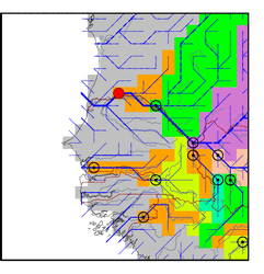
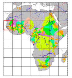
| Station Name (GRDC ID): | Dagana (1812100) | Basin Name: | Senegal |
|---|---|---|---|
| River Name: | Senegal | Next Downstream Station: | None |
| GRDC Country Code: | SG | Distance to Next Downstream Station: | N.A. |
| Start Year [Month]: | 1903 [5] | Upstream Station(s): | Matam (1812300) |
| End Year [Month]: | 1974 [10] | ||
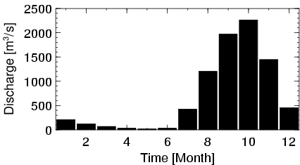
| Mean Discharge: | 687 m3/s | ||
| Minimum Discharge: | 4 m3/s | ||
| Maximum Discharge: | 3260 m3/s | Length of Upstream Mainstem: | 1550 km |
| Mean Interstation Discharge: | -74 m3/s | Distance to Basin Outlet: | 207 km |
| GRDC Catchment Area: | 268000 km2 | STN Catchment Area: | 793731 km2 |
| GRDC Interstation Area: | 38000 km2 | STN Interstation Area: | 29560 km2 |
| GRDC Station Runoff: | 81 mm/yr | STN Station Runoff: | 27 mm/yr |
| GRDC Interstation Runoff: | -61 mm/yr | STN Interstation Runoff: | -79 mm/yr |
| Station Field Descriptions | Basin Field Descriptions | ||
| Download | |
|---|---|
| Site Descriptor Information | Station Time Series Data |
| Hydrograph | Station Data | ||||||||||||||||||||||||||||||||||||||||||||||||||||||||
|---|---|---|---|---|---|---|---|---|---|---|---|---|---|---|---|---|---|---|---|---|---|---|---|---|---|---|---|---|---|---|---|---|---|---|---|---|---|---|---|---|---|---|---|---|---|---|---|---|---|---|---|---|---|---|---|---|---|
|
| ||||||||||||||||||||||||||||||||||||||||||||||||||||||||
