 |
 |
|
|
| Station Name (GRDC ID): | Nanning (2186500) | Basin Name: | Zhujiang |
|---|---|---|---|
| River Name: | Yujiang | Next Downstream Station: | Wuzhou 3 (2186800) |
| GRDC Country Code: | CI | Distance to Next Downstream Station: | 356 km |
| Start Year [Month]: | 1936 [6] | Upstream Station(s): | None |
| End Year [Month]: | 1984 [12] | ||
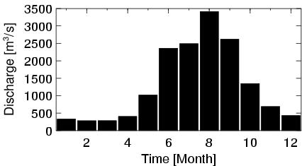
| Mean Discharge: | 1304 m3/s | ||
| Minimum Discharge: | 119 m3/s | ||
| Maximum Discharge: | 7210 m3/s | Length of Upstream Mainstem: | 381 km |
| Mean Interstation Discharge: | 1304 m3/s | Distance to Basin Outlet: | 740 km |
| GRDC Catchment Area: | 75500 km2 | STN Catchment Area: | 76744 km2 |
| GRDC Interstation Area: | 75500 km2 | STN Interstation Area: | 76744 km2 |
| GRDC Station Runoff: | 545 mm/yr | STN Station Runoff: | 536 mm/yr |
| GRDC Interstation Runoff: | 545 mm/yr | STN Interstation Runoff: | 536 mm/yr |
| Station Field Descriptions | Basin Field Descriptions | ||
| Download | |
|---|---|
| Site Descriptor Information | Station Time Series Data |
| Hydrograph | Station Data | ||||||||||||||||||||||||||||||||||||||||||||||||||||||||
|---|---|---|---|---|---|---|---|---|---|---|---|---|---|---|---|---|---|---|---|---|---|---|---|---|---|---|---|---|---|---|---|---|---|---|---|---|---|---|---|---|---|---|---|---|---|---|---|---|---|---|---|---|---|---|---|---|---|
|
| ||||||||||||||||||||||||||||||||||||||||||||||||||||||||
