 |
 |
|
|
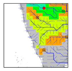
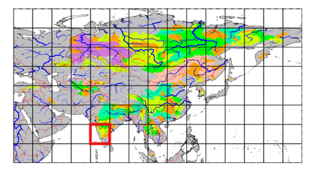
| Station Name (GRDC ID): | Dhalegaon (2856200) | Basin Name: | Godavari |
|---|---|---|---|
| River Name: | Godavari | Next Downstream Station: | Mancherial (2856500) |
| GRDC Country Code: | IN | Distance to Next Downstream Station: | 339 km |
| Start Year [Month]: | 1968 [1] | Upstream Station(s): | None |
| End Year [Month]: | 1979 [12] | ||
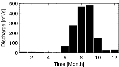
| Mean Discharge: | 126 m3/s | ||
| Minimum Discharge: | 0 m3/s | ||
| Maximum Discharge: | 2059 m3/s | Length of Upstream Mainstem: | 415 km |
| Mean Interstation Discharge: | 126 m3/s | Distance to Basin Outlet: | 839 km |
| GRDC Catchment Area: | 30840 km2 | STN Catchment Area: | 31994 km2 |
| GRDC Interstation Area: | 30840 km2 | STN Interstation Area: | 31994 km2 |
| GRDC Station Runoff: | 129 mm/yr | STN Station Runoff: | 125 mm/yr |
| GRDC Interstation Runoff: | 129 mm/yr | STN Interstation Runoff: | 125 mm/yr |
| Station Field Descriptions | Basin Field Descriptions | ||
| Download | |
|---|---|
| Site Descriptor Information | Station Time Series Data |
| Hydrograph | Station Data | ||||||||||||||||||||||||||||||||||||||||||||||||||||||||
|---|---|---|---|---|---|---|---|---|---|---|---|---|---|---|---|---|---|---|---|---|---|---|---|---|---|---|---|---|---|---|---|---|---|---|---|---|---|---|---|---|---|---|---|---|---|---|---|---|---|---|---|---|---|---|---|---|---|
|
| ||||||||||||||||||||||||||||||||||||||||||||||||||||||||
