 |
 |
|
|
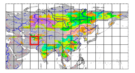
| Station Name (GRDC ID): | Manguzar (2917400) | Basin Name: | Amu-Darya |
|---|---|---|---|
| River Name: | Surkhandarya | Next Downstream Station: | Kerki (2917110) |
| GRDC Country Code: | UZ | Distance to Next Downstream Station: | 230 km |
| Start Year [Month]: | 1932 [1] | Upstream Station(s): | None |
| End Year [Month]: | 1989 [12] | ||
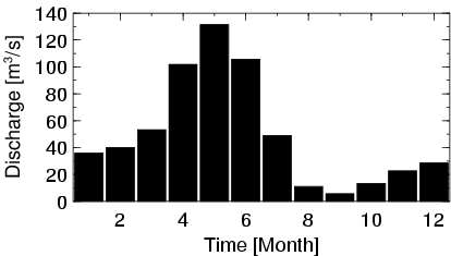
| Mean Discharge: | 50 m3/s | ||
| Minimum Discharge: | 0 m3/s | ||
| Maximum Discharge: | 390 m3/s | Length of Upstream Mainstem: | 241 km |
| Mean Interstation Discharge: | 50 m3/s | Distance to Basin Outlet: | 1237 km |
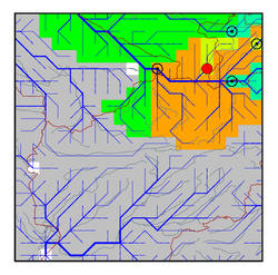
| GRDC Catchment Area: | 13500 km2 | STN Catchment Area: | 12104 km2 |
| GRDC Interstation Area: | 13500 km2 | STN Interstation Area: | 12104 km2 |
| GRDC Station Runoff: | 116 mm/yr | STN Station Runoff: | 130 mm/yr |
| GRDC Interstation Runoff: | 116 mm/yr | STN Interstation Runoff: | 130 mm/yr |
| Station Field Descriptions | Basin Field Descriptions | ||
| Download | |
|---|---|
| Site Descriptor Information | Station Time Series Data |
| Hydrograph | Station Data | ||||||||||||||||||||||||||||||||||||||||||||||||||||||||
|---|---|---|---|---|---|---|---|---|---|---|---|---|---|---|---|---|---|---|---|---|---|---|---|---|---|---|---|---|---|---|---|---|---|---|---|---|---|---|---|---|---|---|---|---|---|---|---|---|---|---|---|---|---|---|---|---|---|
|
| ||||||||||||||||||||||||||||||||||||||||||||||||||||||||
