 |
 |
|
|
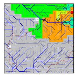
| Station Name (GRDC ID): | Tutkaul (2917900) | Basin Name: | Amu-Darya |
|---|---|---|---|
| River Name: | Vakhsh | Next Downstream Station: | Kerki (2917110) |
| GRDC Country Code: | TA | Distance to Next Downstream Station: | 460 km |
| Start Year [Month]: | 1932 [1] | Upstream Station(s): | Garm (2917920) |
| End Year [Month]: | 1967 [5] | ||
| Mean Discharge: | 639 m3/s | ||
| Minimum Discharge: | 135 m3/s | ||
| Maximum Discharge: | 2170 m3/s | Length of Upstream Mainstem: | 482 km |
| Mean Interstation Discharge: | 310 m3/s | Distance to Basin Outlet: | 1467 km |
| GRDC Catchment Area: | 31200 km2 | STN Catchment Area: | 31137 km2 |
| GRDC Interstation Area: | 11200 km2 | STN Interstation Area: | 12037 km2 |
| GRDC Station Runoff: | 646 mm/yr | STN Station Runoff: | 647 mm/yr |
| GRDC Interstation Runoff: | 872 mm/yr | STN Interstation Runoff: | 811 mm/yr |
| Station Field Descriptions | Basin Field Descriptions | ||
| Download | |
|---|---|
| Site Descriptor Information | Station Time Series Data |
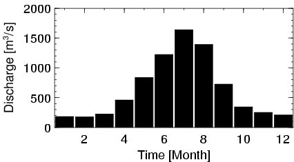
| Hydrograph | Station Data | ||||||||||||||||||||||||||||||||||||||||||||||||||||||||
|---|---|---|---|---|---|---|---|---|---|---|---|---|---|---|---|---|---|---|---|---|---|---|---|---|---|---|---|---|---|---|---|---|---|---|---|---|---|---|---|---|---|---|---|---|---|---|---|---|---|---|---|---|---|---|---|---|---|
|
| ||||||||||||||||||||||||||||||||||||||||||||||||||||||||
