 |
 |
|
|
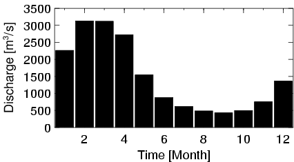
| Station Name (GRDC ID): | Fazenda Telesforo (3649414) | Basin Name: | Tocantins |
|---|---|---|---|
| River Name: | Rio Araguaia | Next Downstream Station: | Conceicao do Araguaia (3649416) |
| GRDC Country Code: | BZ | Distance to Next Downstream Station: | 456 km |
| Start Year [Month]: | 1969 [9] | Upstream Station(s): | Araguaiana (3649412) |
| End Year [Month]: | 1987 [1] | ||
| Mean Discharge: | 1482 m3/s | ||
| Minimum Discharge: | 188 m3/s | ||
| Maximum Discharge: | 5147 m3/s | Length of Upstream Mainstem: | 797 km |
| Mean Interstation Discharge: | 567 m3/s | Distance to Basin Outlet: | 1492 km |
| GRDC Catchment Area: | 131600 km2 | STN Catchment Area: | 134108 km2 |
| GRDC Interstation Area: | 80670 km2 | STN Interstation Area: | 77785 km2 |
| GRDC Station Runoff: | 355 mm/yr | STN Station Runoff: | 349 mm/yr |
| GRDC Interstation Runoff: | 222 mm/yr | STN Interstation Runoff: | 230 mm/yr |
| Station Field Descriptions | Basin Field Descriptions | ||
| Download | |
|---|---|
| Site Descriptor Information | Station Time Series Data |
| Hydrograph | Station Data | ||||||||||||||||||||||||||||||||||||||||||||||||||||||||
|---|---|---|---|---|---|---|---|---|---|---|---|---|---|---|---|---|---|---|---|---|---|---|---|---|---|---|---|---|---|---|---|---|---|---|---|---|---|---|---|---|---|---|---|---|---|---|---|---|---|---|---|---|---|---|---|---|---|
|
| ||||||||||||||||||||||||||||||||||||||||||||||||||||||||
