 |
 |
|
|
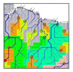
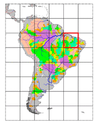
| Station Name (GRDC ID): | Conceicao do Araguaia (3649416) | Basin Name: | Tocantins |
|---|---|---|---|
| River Name: | Rio Araguaia | Next Downstream Station: | Xambioa (3649418) |
| GRDC Country Code: | BZ | Distance to Next Downstream Station: | 245 km |
| Start Year [Month]: | 1969 [1] | Upstream Station(s): | Jacinto (3649211) Fazenda Telesforo (3649414) Santo Antonio do Leverger (3649619) |
| End Year [Month]: | 1987 [6] | ||
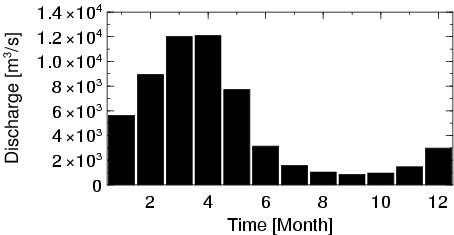
| Mean Discharge: | 4858 m3/s | ||
| Minimum Discharge: | 3 m3/s | ||
| Maximum Discharge: | 23998 m3/s | Length of Upstream Mainstem: | 1276 km |
| Mean Interstation Discharge: | 2320 m3/s | Distance to Basin Outlet: | 1036 km |
| GRDC Catchment Area: | 320290 km2 | STN Catchment Area: | 315378 km2 |
| GRDC Interstation Area: | 119533 km2 | STN Interstation Area: | 112369 km2 |
| GRDC Station Runoff: | 478 mm/yr | STN Station Runoff: | 486 mm/yr |
| GRDC Interstation Runoff: | 612 mm/yr | STN Interstation Runoff: | 651 mm/yr |
| Station Field Descriptions | Basin Field Descriptions | ||
| Download | |
|---|---|
| Site Descriptor Information | Station Time Series Data |
| Hydrograph | Station Data | ||||||||||||||||||||||||||||||||||||||||||||||||||||||||
|---|---|---|---|---|---|---|---|---|---|---|---|---|---|---|---|---|---|---|---|---|---|---|---|---|---|---|---|---|---|---|---|---|---|---|---|---|---|---|---|---|---|---|---|---|---|---|---|---|---|---|---|---|---|---|---|---|---|
|
| ||||||||||||||||||||||||||||||||||||||||||||||||||||||||
