 |
 |
|
|
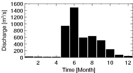
| Station Name (GRDC ID): | Hughes, Alas. (4103500) | Basin Name: | Yukon |
|---|---|---|---|
| River Name: | Koyukuk | Next Downstream Station: | Kaltag, Alas. (4103300) |
| GRDC Country Code: | US | Distance to Next Downstream Station: | 314 km |
| Start Year [Month]: | 1965 [1] | Upstream Station(s): | None |
| End Year [Month]: | 1982 [9] | ||
| Mean Discharge: | 382 m3/s | ||
| Minimum Discharge: | 7 m3/s | ||
| Maximum Discharge: | 2850 m3/s | Length of Upstream Mainstem: | 414 km |
| Mean Interstation Discharge: | 382 m3/s | Distance to Basin Outlet: | 979 km |
| GRDC Catchment Area: | 48433 km2 | STN Catchment Area: | 50305 km2 |
| GRDC Interstation Area: | 48433 km2 | STN Interstation Area: | 50305 km2 |
| GRDC Station Runoff: | 248 mm/yr | STN Station Runoff: | 239 mm/yr |
| GRDC Interstation Runoff: | 248 mm/yr | STN Interstation Runoff: | 239 mm/yr |
| Station Field Descriptions | Basin Field Descriptions | ||
| Download | |
|---|---|
| Site Descriptor Information | Station Time Series Data |
| Hydrograph | Station Data | ||||||||||||||||||||||||||||||||||||||||||||||||||||||||
|---|---|---|---|---|---|---|---|---|---|---|---|---|---|---|---|---|---|---|---|---|---|---|---|---|---|---|---|---|---|---|---|---|---|---|---|---|---|---|---|---|---|---|---|---|---|---|---|---|---|---|---|---|---|---|---|---|---|
|
| ||||||||||||||||||||||||||||||||||||||||||||||||||||||||
