 |
 |
|
|
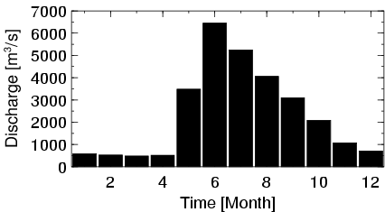
| Station Name (GRDC ID): | Eagle (4103800) | Basin Name: | Yukon |
|---|---|---|---|
| River Name: | Yukon River | Next Downstream Station: | near Stevens Village (4103550) |
| GRDC Country Code: | US | Distance to Next Downstream Station: | 610 km |
| Start Year [Month]: | 1950 [6] | Upstream Station(s): | Dawson (4203200) |
| End Year [Month]: | 1993 [9] | ||
| Mean Discharge: | 2359 m3/s | ||
| Minimum Discharge: | 201 m3/s | ||
| Maximum Discharge: | 12768 m3/s | Length of Upstream Mainstem: | 970 km |
| Mean Interstation Discharge: | 199 m3/s | Distance to Basin Outlet: | 1770 km |
| GRDC Catchment Area: | 293965 km2 | STN Catchment Area: | 295238 km2 |
| GRDC Interstation Area: | 29965 km2 | STN Interstation Area: | 30742 km2 |
| GRDC Station Runoff: | 253 mm/yr | STN Station Runoff: | 252 mm/yr |
| GRDC Interstation Runoff: | 210 mm/yr | STN Interstation Runoff: | 204 mm/yr |
| Station Field Descriptions | Basin Field Descriptions | ||
| Download | |
|---|---|
| Site Descriptor Information | Station Time Series Data |
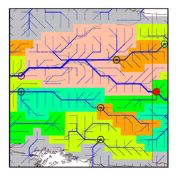
| Hydrograph | Station Data | ||||||||||||||||||||||||||||||||||||||||||||||||||||||||
|---|---|---|---|---|---|---|---|---|---|---|---|---|---|---|---|---|---|---|---|---|---|---|---|---|---|---|---|---|---|---|---|---|---|---|---|---|---|---|---|---|---|---|---|---|---|---|---|---|---|---|---|---|---|---|---|---|---|
|
| ||||||||||||||||||||||||||||||||||||||||||||||||||||||||
