 |
 |
|
|
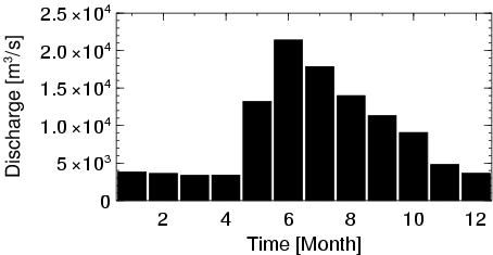
| Station Name (GRDC ID): | Arctic Red River (4208025) | Basin Name: | Mackenzie |
|---|---|---|---|
| River Name: | Mackenzie River | Next Downstream Station: | None |
| GRDC Country Code: | CN | Distance to Next Downstream Station: | N.A. |
| Start Year [Month]: | 1972 [8] | Upstream Station(s): | Norman Wells (4208150) |
| End Year [Month]: | 1992 [12] | ||
| Mean Discharge: | 9119 m3/s | ||
| Minimum Discharge: | 2129 m3/s | ||
| Maximum Discharge: | 27703 m3/s | Length of Upstream Mainstem: | 3447 km |
| Mean Interstation Discharge: | 795 m3/s | Distance to Basin Outlet: | 292 km |
| GRDC Catchment Area: | 1660000 km2 | STN Catchment Area: | 1678481 km2 |
| GRDC Interstation Area: | 90000 km2 | STN Interstation Area: | 108883 km2 |
| GRDC Station Runoff: | 173 mm/yr | STN Station Runoff: | 171 mm/yr |
| GRDC Interstation Runoff: | 278 mm/yr | STN Interstation Runoff: | 230 mm/yr |
| Station Field Descriptions | Basin Field Descriptions | ||
| Download | |
|---|---|
| Site Descriptor Information | Station Time Series Data |
| Hydrograph | Station Data | ||||||||||||||||||||||||||||||||||||||||||||||||||||||||
|---|---|---|---|---|---|---|---|---|---|---|---|---|---|---|---|---|---|---|---|---|---|---|---|---|---|---|---|---|---|---|---|---|---|---|---|---|---|---|---|---|---|---|---|---|---|---|---|---|---|---|---|---|---|---|---|---|---|
|
| ||||||||||||||||||||||||||||||||||||||||||||||||||||||||
