 |
 |
|
|
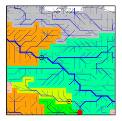
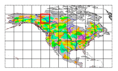
| Station Name (GRDC ID): | Fort Liard (4208280) | Basin Name: | Mackenzie |
|---|---|---|---|
| River Name: | Liard River | Next Downstream Station: | Norman Wells (4208150) |
| GRDC Country Code: | CN | Distance to Next Downstream Station: | 797 km |
| Start Year [Month]: | 1966 [1] | Upstream Station(s): | Lower Crossing (4208270) |
| End Year [Month]: | 1984 [12] | ||
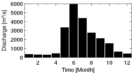
| Mean Discharge: | 1878 m3/s | ||
| Minimum Discharge: | 182 m3/s | ||
| Maximum Discharge: | 9060 m3/s | Length of Upstream Mainstem: | 729 km |
| Mean Interstation Discharge: | 735 m3/s | Distance to Basin Outlet: | 1545 km |
| GRDC Catchment Area: | 222000 km2 | STN Catchment Area: | 219420 km2 |
| GRDC Interstation Area: | 118000 km2 | STN Interstation Area: | 115962 km2 |
| GRDC Station Runoff: | 267 mm/yr | STN Station Runoff: | 270 mm/yr |
| GRDC Interstation Runoff: | 196 mm/yr | STN Interstation Runoff: | 200 mm/yr |
| Station Field Descriptions | Basin Field Descriptions | ||
| Download | |
|---|---|
| Site Descriptor Information | Station Time Series Data |
| Hydrograph | Station Data | ||||||||||||||||||||||||||||||||||||||||||||||||||||||||
|---|---|---|---|---|---|---|---|---|---|---|---|---|---|---|---|---|---|---|---|---|---|---|---|---|---|---|---|---|---|---|---|---|---|---|---|---|---|---|---|---|---|---|---|---|---|---|---|---|---|---|---|---|---|---|---|---|---|
|
| ||||||||||||||||||||||||||||||||||||||||||||||||||||||||
