 |
 |
|
|
| Station Name (GRDC ID): | Athabasca (4208870) | Basin Name: | Mackenzie |
|---|---|---|---|
| River Name: | Athabasca River | Next Downstream Station: | below Mcmurray (4208730) |
| GRDC Country Code: | CN | Distance to Next Downstream Station: | 300 km |
| Start Year [Month]: | 1952 [1] | Upstream Station(s): | None |
| End Year [Month]: | 1988 [12] | ||
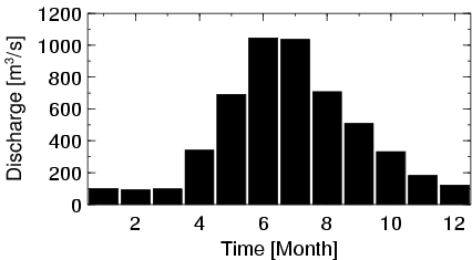
| Mean Discharge: | 438 m3/s | ||
| Minimum Discharge: | 56 m3/s | ||
| Maximum Discharge: | 2280 m3/s | Length of Upstream Mainstem: | 669 km |
| Mean Interstation Discharge: | 438 m3/s | Distance to Basin Outlet: | 2756 km |
| GRDC Catchment Area: | 74600 km2 | STN Catchment Area: | 77848 km2 |
| GRDC Interstation Area: | 74600 km2 | STN Interstation Area: | 77848 km2 |
| GRDC Station Runoff: | 185 mm/yr | STN Station Runoff: | 177 mm/yr |
| GRDC Interstation Runoff: | 185 mm/yr | STN Interstation Runoff: | 177 mm/yr |
| Station Field Descriptions | Basin Field Descriptions | ||
| Download | |
|---|---|
| Site Descriptor Information | Station Time Series Data |
| Hydrograph | Station Data | ||||||||||||||||||||||||||||||||||||||||||||||||||||||||
|---|---|---|---|---|---|---|---|---|---|---|---|---|---|---|---|---|---|---|---|---|---|---|---|---|---|---|---|---|---|---|---|---|---|---|---|---|---|---|---|---|---|---|---|---|---|---|---|---|---|---|---|---|---|---|---|---|---|
|
| ||||||||||||||||||||||||||||||||||||||||||||||||||||||||
