 |
 |
|
|
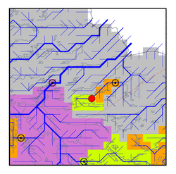
| Station Name (GRDC ID): | near Island Lake (4214330) | Basin Name: | Hayes |
|---|---|---|---|
| River Name: | Island Lake River | Next Downstream Station: | Outlet of Gods Lake (4214350) |
| GRDC Country Code: | CN | Distance to Next Downstream Station: | 160 km |
| Start Year [Month]: | 1934 [1] | Upstream Station(s): | None |
| End Year [Month]: | 1964 [12] | ||
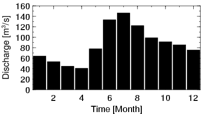
| Mean Discharge: | 86 m3/s | ||
| Minimum Discharge: | 20 m3/s | ||
| Maximum Discharge: | 284 m3/s | Length of Upstream Mainstem: | 260 km |
| Mean Interstation Discharge: | 86 m3/s | Distance to Basin Outlet: | 438 km |
| GRDC Catchment Area: | 14000 km2 | STN Catchment Area: | 12730 km2 |
| GRDC Interstation Area: | 14000 km2 | STN Interstation Area: | 12730 km2 |
| GRDC Station Runoff: | 194 mm/yr | STN Station Runoff: | 213 mm/yr |
| GRDC Interstation Runoff: | 194 mm/yr | STN Interstation Runoff: | 213 mm/yr |
| Station Field Descriptions | Basin Field Descriptions | ||
| Download | |
|---|---|
| Site Descriptor Information | Station Time Series Data |
| Hydrograph | Station Data | ||||||||||||||||||||||||||||||||||||||||||||||||||||||||
|---|---|---|---|---|---|---|---|---|---|---|---|---|---|---|---|---|---|---|---|---|---|---|---|---|---|---|---|---|---|---|---|---|---|---|---|---|---|---|---|---|---|---|---|---|---|---|---|---|---|---|---|---|---|---|---|---|---|
|
| ||||||||||||||||||||||||||||||||||||||||||||||||||||||||
