 |
 |
|
|
| Station Name (GRDC ID): | Birchbank (4215200) | Basin Name: | Columbia |
|---|---|---|---|
| River Name: | Columbia River | Next Downstream Station: | The Dalles, Oreg. (4115200) |
| GRDC Country Code: | CN | Distance to Next Downstream Station: | 799 km |
| Start Year [Month]: | 1937 [10] | Upstream Station(s): | near Copeland (4215320) |
| End Year [Month]: | 1984 [12] | ||
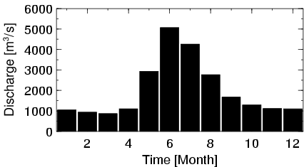
| Mean Discharge: | 2013 m3/s | ||
| Minimum Discharge: | 172 m3/s | ||
| Maximum Discharge: | 9340 m3/s | Length of Upstream Mainstem: | 748 km |
| Mean Interstation Discharge: | 1558 m3/s | Distance to Basin Outlet: | 1098 km |
| GRDC Catchment Area: | 88100 km2 | STN Catchment Area: | 88953 km2 |
| GRDC Interstation Area: | 53400 km2 | STN Interstation Area: | 50907 km2 |
| GRDC Station Runoff: | 721 mm/yr | STN Station Runoff: | 714 mm/yr |
| GRDC Interstation Runoff: | 920 mm/yr | STN Interstation Runoff: | 965 mm/yr |
| Station Field Descriptions | Basin Field Descriptions | ||
| Download | |
|---|---|
| Site Descriptor Information | Station Time Series Data |
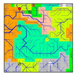
| Hydrograph | Station Data | ||||||||||||||||||||||||||||||||||||||||||||||||||||||||
|---|---|---|---|---|---|---|---|---|---|---|---|---|---|---|---|---|---|---|---|---|---|---|---|---|---|---|---|---|---|---|---|---|---|---|---|---|---|---|---|---|---|---|---|---|---|---|---|---|---|---|---|---|---|---|---|---|---|
|
| ||||||||||||||||||||||||||||||||||||||||||||||||||||||||
