 |
 |
|
|
| Station Name (GRDC ID): | near Copeland (4215320) | Basin Name: | Columbia |
|---|---|---|---|
| River Name: | Kootenai | Next Downstream Station: | Birchbank (4215200) |
| GRDC Country Code: | CN | Distance to Next Downstream Station: | 224 km |
| Start Year [Month]: | 1929 [5] | Upstream Station(s): | Wardner (4215705) |
| End Year [Month]: | 1984 [12] | ||
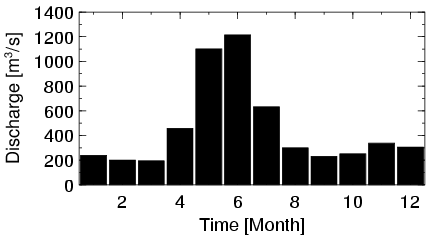
| Mean Discharge: | 455 m3/s | ||
| Minimum Discharge: | 58 m3/s | ||
| Maximum Discharge: | 4980 m3/s | Length of Upstream Mainstem: | 535 km |
| Mean Interstation Discharge: | 247 m3/s | Distance to Basin Outlet: | 1323 km |
| GRDC Catchment Area: | 34700 km2 | STN Catchment Area: | 38047 km2 |
| GRDC Interstation Area: | 21100 km2 | STN Interstation Area: | 22359 km2 |
| GRDC Station Runoff: | 414 mm/yr | STN Station Runoff: | 377 mm/yr |
| GRDC Interstation Runoff: | 369 mm/yr | STN Interstation Runoff: | 348 mm/yr |
| Station Field Descriptions | Basin Field Descriptions | ||
| Download | |
|---|---|
| Site Descriptor Information | Station Time Series Data |
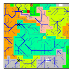
| Hydrograph | Station Data | ||||||||||||||||||||||||||||||||||||||||||||||||||||||||
|---|---|---|---|---|---|---|---|---|---|---|---|---|---|---|---|---|---|---|---|---|---|---|---|---|---|---|---|---|---|---|---|---|---|---|---|---|---|---|---|---|---|---|---|---|---|---|---|---|---|---|---|---|---|---|---|---|---|
|
| ||||||||||||||||||||||||||||||||||||||||||||||||||||||||
