 |
 |
|
|
| Station Name (GRDC ID): | Wardner (4215705) | Basin Name: | Columbia |
|---|---|---|---|
| River Name: | Kootenay | Next Downstream Station: | near Copeland (4215320) |
| GRDC Country Code: | CN | Distance to Next Downstream Station: | 281 km |
| Start Year [Month]: | 1937 [1] | Upstream Station(s): | None |
| End Year [Month]: | 1971 [12] | ||
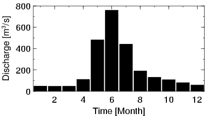
| Mean Discharge: | 209 m3/s | ||
| Minimum Discharge: | 30 m3/s | ||
| Maximum Discharge: | 1240 m3/s | Length of Upstream Mainstem: | 253 km |
| Mean Interstation Discharge: | 209 m3/s | Distance to Basin Outlet: | 1604 km |
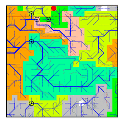
| GRDC Catchment Area: | 13600 km2 | STN Catchment Area: | 15688 km2 |
| GRDC Interstation Area: | 13600 km2 | STN Interstation Area: | 15688 km2 |
| GRDC Station Runoff: | 483 mm/yr | STN Station Runoff: | 419 mm/yr |
| GRDC Interstation Runoff: | 483 mm/yr | STN Interstation Runoff: | 419 mm/yr |
| Station Field Descriptions | Basin Field Descriptions | ||
| Download | |
|---|---|
| Site Descriptor Information | Station Time Series Data |
| Hydrograph | Station Data | ||||||||||||||||||||||||||||||||||||||||||||||||||||||||
|---|---|---|---|---|---|---|---|---|---|---|---|---|---|---|---|---|---|---|---|---|---|---|---|---|---|---|---|---|---|---|---|---|---|---|---|---|---|---|---|---|---|---|---|---|---|---|---|---|---|---|---|---|---|---|---|---|---|
|
| ||||||||||||||||||||||||||||||||||||||||||||||||||||||||
