 |
 |
|
|
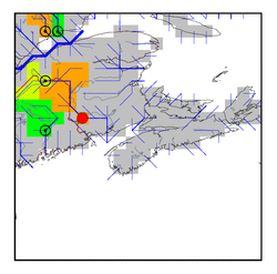
| Station Name (GRDC ID): | Pokiok (4231600) | Basin Name: | Saint John |
|---|---|---|---|
| River Name: | St.John | Next Downstream Station: | None |
| GRDC Country Code: | CN | Distance to Next Downstream Station: | N.A. |
| Start Year [Month]: | 1918 [9] | Upstream Station(s): | Fort Kent (4231200) |
| End Year [Month]: | 1967 [9] | ||
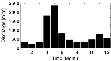
| Mean Discharge: | 728 m3/s | ||
| Minimum Discharge: | 75 m3/s | ||
| Maximum Discharge: | 4540 m3/s | Length of Upstream Mainstem: | 466 km |
| Mean Interstation Discharge: | 454 m3/s | Distance to Basin Outlet: | 189 km |
| GRDC Catchment Area: | 38800 km2 | STN Catchment Area: | 37966 km2 |
| GRDC Interstation Area: | 24100 km2 | STN Interstation Area: | 25317 km2 |
| GRDC Station Runoff: | 591 mm/yr | STN Station Runoff: | 604 mm/yr |
| GRDC Interstation Runoff: | 594 mm/yr | STN Interstation Runoff: | 566 mm/yr |
| Station Field Descriptions | Basin Field Descriptions | ||
| Download | |
|---|---|
| Site Descriptor Information | Station Time Series Data |
| Hydrograph | Station Data | ||||||||||||||||||||||||||||||||||||||||||||||||||||||||
|---|---|---|---|---|---|---|---|---|---|---|---|---|---|---|---|---|---|---|---|---|---|---|---|---|---|---|---|---|---|---|---|---|---|---|---|---|---|---|---|---|---|---|---|---|---|---|---|---|---|---|---|---|---|---|---|---|---|
|
| ||||||||||||||||||||||||||||||||||||||||||||||||||||||||
