 |
 |
|
|
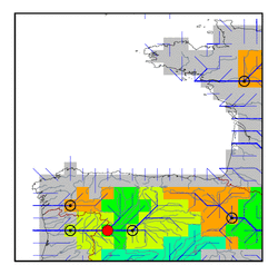
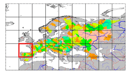
| Station Name (GRDC ID): | Puente Pino (6212420) | Basin Name: | Douro |
|---|---|---|---|
| River Name: | Duero | Next Downstream Station: | Regua (6112090) |
| GRDC Country Code: | SP | Distance to Next Downstream Station: | 125 km |
| Start Year [Month]: | 1943 [10] | Upstream Station(s): | Villachica (6212400) |
| End Year [Month]: | 1991 [12] | ||
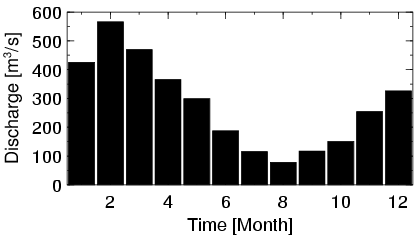
| Mean Discharge: | 279 m3/s | ||
| Minimum Discharge: | 14 m3/s | ||
| Maximum Discharge: | 2312 m3/s | Length of Upstream Mainstem: | 346 km |
| Mean Interstation Discharge: | 137 m3/s | Distance to Basin Outlet: | 251 km |
| GRDC Catchment Area: | 63160 km2 | STN Catchment Area: | 66878 km2 |
| GRDC Interstation Area: | 21304 km2 | STN Interstation Area: | 25296 km2 |
| GRDC Station Runoff: | 140 mm/yr | STN Station Runoff: | 132 mm/yr |
| GRDC Interstation Runoff: | 202 mm/yr | STN Interstation Runoff: | 170 mm/yr |
| Station Field Descriptions | Basin Field Descriptions | ||
| Download | |
|---|---|
| Site Descriptor Information | Station Time Series Data |
| Hydrograph | Station Data | ||||||||||||||||||||||||||||||||||||||||||||||||||||||||
|---|---|---|---|---|---|---|---|---|---|---|---|---|---|---|---|---|---|---|---|---|---|---|---|---|---|---|---|---|---|---|---|---|---|---|---|---|---|---|---|---|---|---|---|---|---|---|---|---|---|---|---|---|---|---|---|---|---|
|
| ||||||||||||||||||||||||||||||||||||||||||||||||||||||||
