 |
 |
|
|
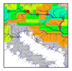
| Station Name (GRDC ID): | Achleiten (6342900) | Basin Name: | Danube |
|---|---|---|---|
| River Name: | Danube | Next Downstream Station: | Stein-Krems (6242400) |
| GRDC Country Code: | DL | Distance to Next Downstream Station: | 141 km |
| Start Year [Month]: | 1901 [1] | Upstream Station(s): | Hofkirchen (6342800) |
| End Year [Month]: | 1991 [12] | ||
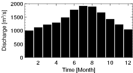
| Mean Discharge: | 1419 m3/s | ||
| Minimum Discharge: | 457 m3/s | ||
| Maximum Discharge: | 4480 m3/s | Length of Upstream Mainstem: | 487 km |
| Mean Interstation Discharge: | 785 m3/s | Distance to Basin Outlet: | 1802 km |
| GRDC Catchment Area: | 76597 km2 | STN Catchment Area: | 76357 km2 |
| GRDC Interstation Area: | 29101 km2 | STN Interstation Area: | 31275 km2 |
| GRDC Station Runoff: | 584 mm/yr | STN Station Runoff: | 586 mm/yr |
| GRDC Interstation Runoff: | 851 mm/yr | STN Interstation Runoff: | 792 mm/yr |
| Station Field Descriptions | Basin Field Descriptions | ||
| Download | |
|---|---|
| Site Descriptor Information | Station Time Series Data |
| Hydrograph | Station Data | ||||||||||||||||||||||||||||||||||||||||||||||||||||||||
|---|---|---|---|---|---|---|---|---|---|---|---|---|---|---|---|---|---|---|---|---|---|---|---|---|---|---|---|---|---|---|---|---|---|---|---|---|---|---|---|---|---|---|---|---|---|---|---|---|---|---|---|---|---|---|---|---|---|
|
| ||||||||||||||||||||||||||||||||||||||||||||||||||||||||
